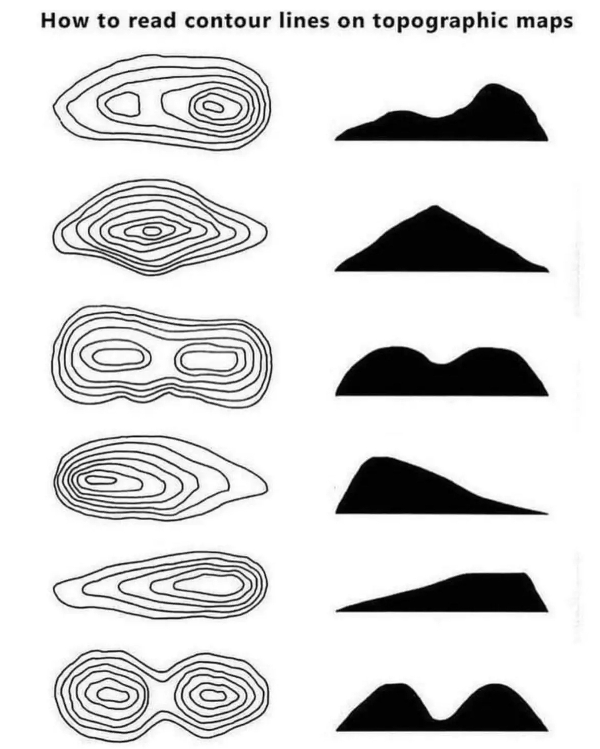
@[email protected] to Cool [email protected]English • 10 months agoHow to read topographic mapsreddthat.comimagemessage-square55fedilinkarrow-up1427arrow-down133
arrow-up1394arrow-down1imageHow to read topographic mapsreddthat.com@[email protected] to Cool [email protected]English • 10 months agomessage-square55fedilink
minus-square@[email protected]linkfedilinkEnglish20•10 months agoDo you have an example, I either never have seen this or never had a depression on a map
minus-square@[email protected]linkfedilinkEnglish32•10 months agoYou want an example of local depression just swing by my place anytime
minus-squareIlliterate DominelinkfedilinkEnglish19•10 months agoHere’s a slide describing how depressions are represented, and here is a topographical map of a sinkhole showing the hashes. That said, I had to look pretty hard for a map with those marks. Numbers are much more common.
minus-square@[email protected]linkfedilinkEnglish6•10 months agoAh, awesome. i appreciate you taking the time to put this together. I dont recall these on maps, but as you said numbers are common. And i typically use the topomap with shading, so shading helps with understanding the terrain
minus-square@[email protected]linkfedilinkEnglish3•10 months agoPage 2 under contours: https://pubs.usgs.gov/gip/TopographicMapSymbols/topomapsymbols.pdf
minus-square@[email protected]linkfedilinkEnglish1•10 months agoA Wisconsin DNR pdf explaining how to identify local depressions on a topo map They are an oddity for sure. But sometimes there’s a local divot that would be interpreted as a small mound without the hatch marks.

Do you have an example, I either never have seen this or never had a depression on a map
You want an example of local depression just swing by my place anytime
heyoooo!
Here’s a slide describing how depressions are represented, and here is a topographical map of a sinkhole showing the hashes.
That said, I had to look pretty hard for a map with those marks. Numbers are much more common.
Ah, awesome. i appreciate you taking the time to put this together. I dont recall these on maps, but as you said numbers are common. And i typically use the topomap with shading, so shading helps with understanding the terrain
Page 2 under contours: https://pubs.usgs.gov/gip/TopographicMapSymbols/topomapsymbols.pdf
Awesome, thankyou
A Wisconsin DNR pdf explaining how to identify local depressions on a topo map
They are an oddity for sure. But sometimes there’s a local divot that would be interpreted as a small mound without the hatch marks.